


The experience of twenty-first century space and time is structured by flows of information, capital, and global influence. Today, these flows seem uniquely enabled by new media. For example, in a digital map published by the research firm Telegeography to represent 2012 Global Internet Traffic, landmasses are torqued into a geometry dictated by data circulation. Colored lines arcing between urban centers suggest material links and geographical connections. As the name “telegeography” implies, however, this map offers an image of the world repatterned according to abstract links rather than physical continuities. It pictures a globe reorganized around virtual flows, a world imagined less as a place than as pattern.
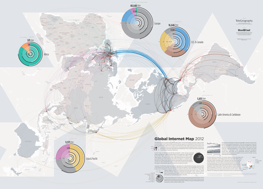
Fig. 1: Global Internet Map 2012 created and published by Telegeography in their online “Map Gallery.”1
Data visualizations like Telegeography’s map of internet traffic help us imagine what Manuel Castells has influentially called the contemporary condition of the Information Age.2 In the first volume of his Information Age trilogy, Rise of the Network Society, Castells argues that digital technologies have reconditioned relationships of space and time such that virtual simultaneities displace material differences. He describes how networks shift away from an emphasis on static sites to an emphasis on dynamic connection. Concrete places become “spaces of flows.”3 In what follows, I argue that “network effects” associated with digital technologies and networks can be traced within broader technological, aesthetic, and cultural transformations. The contemporary rhetoric of digital networks – which identifies new media technologies with new spatiotemporal integrations, new forms of simultaneity and a collapsing of difference and distance – may not disclose the unique conditions of new media as much as update longstanding fantasies that relate the possibility of continuity with aesthetic strategies for producing it.4 Digital media may not introduce new problems of connectivity as much as alter how we imagine connection, prompting us to privilege linking as primary and constitutive of whatever exists as linked.
Alexander Galloway recently put forward the dialectical proposition that, on the one hand, “Only one visualization has ever been made of an information network, for there can only be one” – the kind with a “hub-and-spoke cloud aesthetic” of nodes and links.5 On the other hand, Galloway takes the uniformity of network diagrams as proof that they have almost no semiotic value as representations. He claims “where there is only one there is nothing… a representation of the one is, in fact, a representation of nothing.”6 In what follows, I use the lens of media archeology to turn away from the abstraction of this paradox and analyze specific, historical examples of network visualization that differ from the hub and spoke model, and which suggest other possibilities for picturing connection.
To contest an ahistorical account of networks and network visualization, an account in which digital modes of connection are taken as the model for spatiotemporal connection per se, I offer a “network archeology” of nineteenth century railroad photographs. These photographs demonstrate how strategies for visualizing networks arise within particular contexts that not only constrain ways of seeing and representing connectivity but also govern what kinds of relationships can be thought to constitute a network. By analyzing nineteenth century strategies for picturing connection, I aim to demonstrate that the desire to do so attends every era, reshaped as new technologies recondition how space and time are experienced, represented, and imagined.7
After the Civil War, the construction of transcontinental railroads in the United States coincided with the rise of photography as a mass-medium, and each influenced the other. The desire to visualize train lines drove innovative practices of photographic representation; and the potentials of photography affected how railroad lines were pictured. An important, and under-examined format emerged in this period: photographic sets.8 Photographic sets picturing railroads through series of individual images ordered as virtual journeys along a line. These photographic sets were not geographical models in the manner of maps, nor were they diagrammatic renderings in the manner of contemporary data visualizations. They enacted unusual relationships of part and whole, place and process, image and idea, reality and abstraction.
As a media format and form of popular visual culture, railroad photographs are historically positioned between the dominance of painted panoramas in the nineteenth century and the dominance of cinema in the twentieth century. Styled as a horizontally extended “view,” railroad photographs drew upon conventions of panoramic representation that were well established by the mid-nineteenth century. They also anticipated twentieth century structures of cinematic representation, by coordinating multiple shots into a continuous narrative. Experimenting with a uniquely disjunct form of connection, photographic sets picturing railroad lines expressed emerging possibilities for imagining and representing interconnection across space and time. Their aesthetic strategies resonated with the logic of the train lines under construction, but also, more deeply, with political and economic ideas driving the actual and imagined integration of postwar America.
In turning to nineteenth century railroads and the early history of photography, I deliberately take up a network technology and an imaging technology that new media seem to leave behind. Picturing digital data flows seems a far cry from picturing railroad tracks. The rootedness, the purported indexicality of photography, resists the ethos of contemporary digital media culture. The photographs I consider – fixed, analog, still, black and white – are expressly interested in documenting the specific places and times they materially render. And yet, not only despite, but because of their limitations, nineteenth century photographs of train lines visualized dynamic and emergent possibilities of connectivity. The possibilities they picture suggest potentials for our own moment, when digital networks seem either unrepresentable or sublated into a logic of pure representation. As digital media rework both the reality and representation of connection, railroad photographs invoke an earlier moment when railroads and photographs were mutually altering how connection could be defined and seen.
Photographic Sets
Photography seems ill-suited to picture connection. Announced in Paris and London in 1839, photography emerged as a new medium between the rise of a mass visual culture that was dominated at the turn of the nineteenth century by the painted panorama, and after the turn of the twentieth century by cinema. Connection is the signature of both the panoramic and the cinematic image – a smooth coordination of multiplicity into something that appears singular. A series of photographs, however, remains a series. It lacks both the material, spatial continuity of a painted panoramic image and the perceptual, temporal continuity of a projected cinematic image.
Photographs, almost by definition, are discrete, fixed, specific – each shot frames a unique moment and particular place. Photographs can be spatially juxtaposed edge-to-edge to create a panoramic strip that simulates a continuous view, or temporally juxtaposed in split-second succession to produce the apparent continuity of a cinematic image. For the most part, however, photographs are defined by their insistent singularity – a quality Christian Metz described as that of a piece cut off from the whole, a fragment, a part object.9 To photograph something is to produce a kind of difference, abstracting an image from the thing itself and proliferating multiple instants, angles, and appearances. And yet, by performing paradoxical relationships between the singular and the multiple, the very qualities of photography that seem to work against connection invite us to invest it, prompting us to presume or project forms of coherence between images.
Early photographic sets emerged in relationship with the large-scale and continuous images of painted panoramas, but developed a uniquely discontinuous form of panoramic representation. In the United States of the mid-nineteenth century, as moving panoramas and daguerreotype photography were both flourishing, photographic and panoramic conventions converged as strict, material continuity gave way to the coordination of multiple, discrete “views.” The inventor of the wrap-around panorama boasted, in his 1787 patent, that an artist would “delineate correctly and connectedly every object which presents itself to his view as he turns round” in a given place so that this complete and continuous view could be experienced, in turn, by “an observer turning quite round” in the painted panorama.10 At first, panorama painters relied on photographs produced on-location as a technique to ensure greater accuracy. But correspondences between panoramic and photographic representation grew as painters used photographs to construct images encompassing more than any actual view, and devised the narrative flow of scrolling scenery by selecting and adapting the most compelling preparatory photographs.11 For example, an American painter of moving panoramas, James E. Wilkin, claimed that his 1850 scrolling panorama depicting an overland trail journey west “omit[ted] all sameness to leave out many weary miles” and gathered together the most interesting attractions along the way like a “bouquet of flowers chosen with care.”12 Promotional material for John Wesley Jones’ 1852 Pantoscope of California claimed that over 1500 daguerreotypes had been used in its production.13 While the selection and compression seen in moving panoramas has been theorized as anticipating cinematic forms of editing, photography’s role in mediating this transition from the panoramic to the cinematic has been largely overlooked.14
Attempting to compete with the popularity of painted panoramas, nineteenth century photographers compensated for fact that photographs were small, still, and framed only one place at one time, by publishing photographs in linked and ordered sets.15 Photographic sets arranged multiple, discrete photographs such that a viewer would look at one image at a time, in a pre-arranged sequence. This temporal pacing, and the explicit spacing between one photographic view and the next, introduced possibilities for picturing spatiotemporal expanses that would be impossible to picture as one continuous, unbroken view. Often annotated with captions that added detail about time and place, photographic sets offered compressed visual and narrative representations of processes that spanned otherwise unrepresentable distances and differences.
Just as panorama painters were increasingly relying on photographs and combining multiple views into a condensed and connected format, photographers were increasingly publishing sets of photographs as panoramic spectacles in their own right. An aesthetic shift in panoramic representation away from strict, material continuity toward narrative coherence gave photographers increasing license to group multiple photographs as a spectacle encompassing an extended scale of space and time. For example, in 1851 the daguerreotypist Robert Vance installed a group of three hundred, full plate, daguerreotypes in a show entitled “Views of California,” and in 1858, he promoted a set of successive photographs of California mining communities along the American River, as his “American River Panorama.”16 Producing sets of images organized serially and thematically, spanning explicit temporal and spatial gaps, efforts such as Vance’s developed a uniquely photographic form of panoramic expression relying on the very qualities that seemed to set photography against the panoramic: the temporal and spatial specificity of photographic reference, the stubborn single-ness of the photographic image. Rather than attribute a documentary or narrative force to the exactness or aesthetic quality of any one image, these sets conceived of a composite meaning that was achieved by the overall impact of the coordinated set.
Early photographic sets were sometimes arranged in the form that we would now call panoramic – meant to be viewed edge-to-edge as one continuous image. More often, however, they were non-continuous images of something geographically or temporally continuous, offering piecemeal views of something implicitly understood as a whole, such as a railroad route or a riverboat ride. They often depicted the same experiences popularly represented by moving panoramas: traveling along the Mississippi, overland trail migration to the Western territories, Gold Rush routes, railroad lines, and views of California and San Francisco. What came to constitute an appropriate whole, or an implicit continuity, shifted as photographers responded to the limits of the medium by inventing strategies of coordination. Photographic sets began to express an overall picture that was not manifestly continuous across its multiple images, but only conceptually continuous through the perceptual links produced by the viewer. They offered overarching views that cohered only in the mind’s eye. As the subjects for photographic sets became more expansive, the links thought to connect discrete images also became increasingly abstract. A group of photographs could communicate ideas that appeared through the gaps between images rather than being explicitly depicted in any one: the Civil War, the West, the idea of America.
The nineteenth century practice of producing and consuming photographs as ordered sets resonated with the more abstract problem of coordinating multiple, discrete places and times within overarching systems that were, themselves, in flux. Integrating a series of individual photographs as a coherent visual experience correlated with efforts to organize material differences within abstract flows of coordinated commercial, political, and cultural networks. Photographic sets helped document how material networks of communication, transportation, and trade were concretely reorganizing. By reconditioning how continuity was represented and imagined, photographic sets not only reflected changing possibilities for economic, political and cultural coordination, they also conditioned how these changes took place. Photographic sets combined multiple, discrete, specific images into the implied and abstract coherence of a continuous view. The constructed continuity of this view both assumed and created the constitutive connections it left un-pictured. This strategy of framing the detail, and suggesting an overview that remains out of frame, stands in stark contrast to contemporary network visualizations such as Telegeography’s map of internet traffic. By explicitly picturing patterns of flow and by offering an overarching coordination within a single frame, Telegeography’s map privileges the abstraction of connection while leaving out or abstracting the particularity of everything connected.
Railroad Photographs
In the United States, expanding networks of railroad lines offered a particularly good subject for nineteenth century photographic sets.17 Building transcontinental railroads was a project of huge practical and economic importance in the United States after the gold rush was spurred in 1849, California was incorporated as a state in 1850, and more people settled on the other side of the Sierra Nevada. Materially uniting the country became a pressing national challenge with heavy political and ideological stakes, weighted with ideas of Manifest Destiny and the hope of unifying a country split by Civil War.18 In order to raise money and public support for building railroads, railroad companies commissioned photographers to document the construction and progress of new lines. They sold photographic sets picturing virtual trips along freshly laid tracks as a form of commercial propaganda, and national propaganda, given that these projects were government subsidized.
Photography and the railroads were matched as harbingers of a new technological era, bringing distant vistas into view and connecting space and time in unprecedented ways. The structure of a railroad also seemed especially suited to the structure of a photographic set. Successive photographs, like successive tracks, added up to an expanse that could not be seen from a single or static point of view. The unfolding pattern of tracks within each image suggested a visual trope for the spacing and connection between photographs within the set. The presumed forward movement of the tracks along the rails, and the imagined coherence of the entire railroad line, resonated with the serial structure of the photographic views and their imagined coherence as an overarching view.
Photographic sets offered a view of railroads that differed from the ways train lines were diagrammed, plotted on maps, or represented in scrolling panoramas. In his recent study of transcontinental railroads, Richard White emphasizes their “spatial politics,” pointing out that although maps and diagrams depicted railroad lines “as static” and “a mere overlay on natural space,” the railroad lines actually reordered the spaces they traversed by restructuring political, economic, and perceptual relationships of connection across space and time.19 Cultural theorist Wolfgang Schivelbush identified the perceptual reordering created by railroads with the aesthetic experience of scrolling panoramas, and pointed to the view from a moving train as the prototypical example of a “panoramic perception” he took to be the signature of modernity.20 Film scholar Anne Friedberg, in turn, drew on Schivelbush’s conflation of the railroad passenger’s mobile perspective and the panorama spectator’s virtual view as she offered a history of what she called cinema’s “virtual, mobilized gaze.”21 In this line of thought, taken up by many others since, the scrolling panorama, the railroad, and cinema all fashioned a perceptual continuity modeled after spatiotemporal connections that became increasingly virtualized through the technological and cultural evolution of mass media. Castells’ arguments about digital media follow in this tradition; the digital “flows” he attributes to new media restructure and hyperbolize the virtual continuities identified with the panorama, the railroad, and cinema when they were new.
Fig. 2: The Trans-Siberian Railroad, a moving panorama exhibited at the 1900 World’s Fair in Paris.22
Photography stands apart from the line of inheritance leading from Schivelbush to Castells, and from panoramic to digital forms of virtual connection, to the extent that the singularity, particularity, and detail of the photographic image appears in opposition to, and even as a bulwark against, ways of seeing that would sweep everything up into apparent continuity. For example, although Shivelbush points out the “simultaneous rise of photography” and the “first great railways,” he argues that photography developed in contrast to, and as a form of compensation for, the kind of “panoramic perception” promulgated by the railroad and industrialization at large. He claims, “the intensive experience of the sensuous world, terminated by the industrial revolution, underwent a resurrection in the new institution of photography. Since immediacy, close-ups and foreground had been lost in reality, they appeared particularly attractive in the new medium.”23 In his interpretation, the photographic image is at odds with the panoramic because the panoramic view sees the world at a remove, organized as an abstract continuum, but the photographic image presents the world up-close and in detail, capturing one, individual perspective at a time.
Photographic sets were not at odds with the panoramic, but rather, offered a distinct type of panoramic view, and explored a distinct grammar of connection. Scrolling panoramas represented landscape scenery as it might be seen by a passenger watching through a train window. In contrast, photographic sets tended to picture the railroad line itself, displaying the tracks in the landscape as a spectacle of progress. Photographic sets emphasized the construction and continuity of the line. They conjured the point of view of the train that would travel along the line, and looked toward the blank edge of expectation where new tracks were to be laid. The images were explicitly discrete, but also implicitly connected. The suggested links between photographs were presumed to match spatiotemporal connections that actually existed, and which were actively being constructed, between one place and the next along the line.
Some sets of railroad photographs were published as series of individual plates, or as mounted cards, but the most notable sets were published in luxurious, bound books that were commissioned by those with commercial interests in the railroads, and sold as expensive collectors’ items or given as gifts to wealthy donors. For example, the Union Pacific Railroad commissioned A. J. Russell, a former Civil War photographer who had worked as part of the U.S. Military Railroad Construction Corps, to document the construction of the transcontinental railroad from 1868-1872. In 1869, the year that the Golden Spike was driven, with great fanfare, to complete the first transcontinental line, a handsome volume of these photographs was published titled The Great West Illustrated in a Series of Photographic Views Across the Continent: Taken Along the Line of the Union Pacific Railroad, West from Omaha, Nebraska.24 The bound collection of photographs not only takes advantage of the serial format of the book’s pages, but also uses the apparatus of a table of contents, and short titles or captions below each photograph, to assert additional structures of continuity. The title page of the album explains that the annotated table of contents gives “a brief description of each view, its peculiarities, characteristics, and connection with the different points on the road.” While the photographs each picture a distinct place and time, the “peculiarities” of the “different points” are carefully situated in mutual “connection” to one another and within the overarching coherence of the whole set, the railroad line, and the natural landscape that the volume’s title refers to, not merely as the country, but as the “continent.”
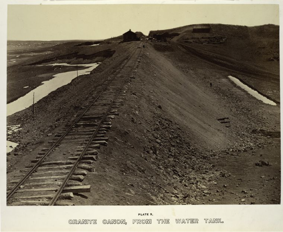
Fig. 3: Plate 2 of A.J. Russell’s Photographic Views Across the Continent: Taken Along the Line of the Union Pacific Railroad, West from Omaha, Nebraska (1869).
Russell’s Across the Continent series borrows from the informational style of survey photography that had supported the planning of railroads, but also exhibits emerging conventions of a photographic album presented as travelogue.25 The views framed in each photographic image often include a human figure positioned in the middle-distance, part-way between the imagined position of the camera or viewer and the vanishing point of the horizon into which the tracks are imagined to continue. Facing away from the camera, and toward the unseen continuation of the tracks, these figures act as avatars for the spectator and help relate the progress of a train threading through this landscape with the virtual progress of the viewer looking through these photographic scenes. Many of Russell’s photographs are aesthetically stunning, especially when printed in the large scale of the bound album. Beyond offering a photographic map of the railroad line, they emphasize dramatic excavations and bridges that produced connections through mountains and across ravines. They juxtapose the contours of rivers and cliffs with the curves and lines of metal rails and wooden tracks. They suggest multiple ways of interpreting the intersections and clashes of scale that railroads were introducing between the environment, engineering, and the human body.
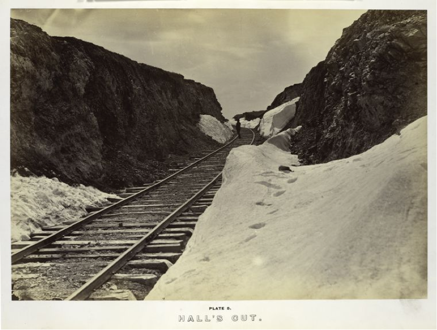
Fig. 4: Plate 5 of A.J. Russell’s Photographic Views Across the Continent: Taken Along the Line of the Union Pacific Railroad, West from Omaha, Nebraska (1869).
If Russell’s images lean toward Romantic landscape paintings, other nineteenth century photographic sets picturing railroads anticipate photojournalism or exhibit the documentation style of science and engineering. Foregrounding their exhaustive coverage of a line, they threaten tedium, seeming to follow tracks plank by plank and using careful numbering and captions to orient the viewer each step along the journey. To create coherence across a series of discrete photographs, these sets use spatial cues to correlate the relative position of one photograph in the set with the relative positions of the actual place pictured along the railroad line. Consider, for example, Alexander Gardner’s 1867 series of one hundred sixty photographs titled Across the Continent on the Kansas Pacific Railroad: Route of the 35th Parallel.26
In two successive plates the captions indicate both the amount of time that passed between the capture of one image and the next, and also the exact mileage separating the two sites depicted in the photographs. The caption for plate 38 indicates this image was taken “On the Great Plains, Kansas, September, 1867, 256 miles west of the Missouri River.” The caption for the following plate, numbered 39, indicates this image was taken “Laying track 300 miles west of the Missouri River, 19th October 1867.” The captions invite the viewer who moves through these photographs to virtually recreate a narrative of progressive construction along the line and the photographers’ own journey “across the continent.” Two forms of progress mutually enforce and guarantee one another: the material unfolding of the railroad tracks, laid one by one in a continuous line across the continuous landscape, and the visual unfolding of the photographs appearing one by one in a connected set as a coherent view.
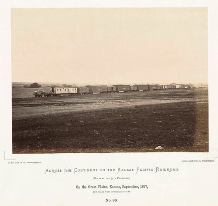
Fig. 5: Plate 38 of Alexander Gardner’s Across the Continent on the Kansas Pacific Railroad (1869, Plate photographed 1867).
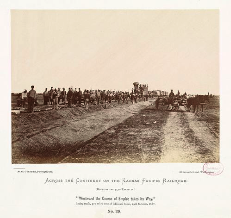
Fig. 6: Plate 39 of Alexander Gardner’s Across the Continent on the Kansas Pacific Railroad (1869, plate photographed 1867).
More was at stake in series like these than the material reality of the expanding tracks and the conventions of photographic depiction. The narrative and perceptual impact of experiencing the railroad represented this way, flipping through a strictly ordered set photographs, helped not only to construct the idea of the railroad’s inevitable unfolding, but also to align this with a sense of the steady progress of Westward expansion. Plate 39 of Gardner’s Across the Continent series was one of the most popular of the set, and bore the dramatic title “Westward the Course of Empire makes its Way.” Placing this phrase in quotations in the caption, Gardner acknowledges he refers to the title of a painting by Emanuel Leutze, which was commissioned in 1861 for display in the White House. Blending western tropes of the frontier and the gold rush, the painting celebrates the idea that it would be the United States’ manifest destiny to expand and overtake European nations as a new imperial power.
Viewing a set of photographs taken along a railroad line, viewers were imaginatively stitching together the railroad tracks, conceiving the overarching expanse of the railroad. But they were also stitching together the background, imagining the tracks traversing a unified landscape and a nation integrated across state lines. Photographic sets picturing railroad lines asked viewers to coordinate discrete images into a virtual coherence at the level of representation, and this virtual coherence referred back to a purportedly “natural” continuity that pre-exited its picturing. The apparent continuity of the photographic journey suggested, at once, the built cohesion of the railroad line, the “natural” coherence of the western landscape, and the political and economic unity of the United States. So, while sets of railroad photographs presumed to document the actual continuity of the tracks, the line, and the journey, they actually helped produce conceptual continuities that exceeded direct picturing.
Photographic series picturing railroads correlate with other co-emerging forms of photographic expression that also attempted to produce overarching narratives from fragmented views. For example, just one year before he published his Across the Continent series, Alexander Gardener gained renown for a series of Civil War photographs titled Alexander Gardner’s Photographic Sketchbook of the War. This volume bound several hundred photographs by multiple photographers into a linear format with text captions, attempting to offer a panoramic perspective of the war. The idea of what constituted a panoramic perspective had changed and, as photography offered new aesthetic strategies for representing and suggesting connections, more abstract forms of interconnection also seemed possible to picture. The modular and disjunctive forms of interconnection that photographic sets mobilized met a need to imagine how an expanding range of spatiotemporal difference could be incorporated into a coherent framework. Strategies for picturing visual, conceptual, and narrative continuity in photographic sets resonate with broader nineteenth century ambitions efforts to coordinate integrated technical, political, and economic networks and to orchestrate a shared historical narrative and national perspective.27
Stereographic Railroad Sets
Photographic sets such as A. J. Russell’s and Alexander Gardner’s serial images of the transcontinental railroads echoed the popular spectacle of moving panoramas but also correlated with new practices of viewing photographs that emerged alongside the stereoscope. Stereo photography developed in the second half of the nineteenth century just as photographers were finding new ways to express panoramic aspirations through photographic series. As the idea of the panoramic took hold as a broad cultural logic, the visual world appeared as a panoramic spectacle that photography might collect and organize.28 As stereographs became massively popular, stereo photography was imagined as a potentially comprehensive form of representation, “the general panorama of the world.”29
Discussions of the stereoscope, in the nineteenth century and today, most often focus on the illusion of visual depth: a stereoscopic view prompts its spectator to coordinate two distinct images, captured from slightly different vantage points, into a perceptual impression of a three-dimensional scene.30 But another important dimension of stereoscopic representation only appears when it is considered in the context of sets and series. The stereograph is an inherently multiple image, two images combined as one visual impression. But, from the start, stereo photographs were multiple in another way as well: they were primarily produced, collected, sold, and viewed in sets and series. The hand-held stereoscopes devised by Wheatstone, Brewster, and Holmes held only one image at a time. But by the 1860’s many devices existed for storing and viewing stereo images in prearranged sequences.31
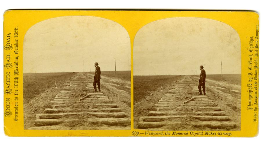
Much of the serial photography of American railroads in the second half of the nineteenth century was stereographic. Many notable photographers, such as Eadweard Muybridge, Carleton Watkins, William Jackson, and Alexander Gardner produced stereoviews of railroads. Some sets were extensive, such as the one hundred views published in 1866 by John Carbut. Titled “Union Pacific Rail Road Excursion to the 100th Meridian,” the set was commissioned by promoters of the railroad as a form of propaganda in order to help raise funds.32 Other examples abound, and historian of the stereograph William Darrah claims “there was scarcely a railroad line in operation in the US before 1890 that was not well stereographed.”33
Photographers might capture standard and stereo photographs on the same trip, and might publish a series of single-plate images in an expensive bound album while at the same time publishing a less expensive set of stereographic cards. As is the case with a great deal of nineteenth century photography, images presented as single-plate photographs may have been printed from one half of a pair of plates initially exposed as a stereoscopic photograph. Although A. J. Russell’s Across the Continent photographs were published as single-frame images in the luxurious, bound volume of 1869, they were captured with a glass-plate stereographic camera and were also published as stereographs, sets of paired images mounted on small, numbered cards.34 The images, as seen in the bound book, aspire to the scale and status of landscape paintings, but their compositions also express conventions of stereoscopic photography, which framed dramatic relative dimensions to exaggerate depth. The use of small human figures in these images was a particularly common trope of stereographic representation, helping to associate the embodied, perceptual depth experienced by the viewer with the position of this pictured spectator held within the virtual depth of the scene.
Stereographic railroad photographs constructed modes of continuity that leveraged the immersive effects of stereoscopic depiction in correlation with the conceptual coordination of multiple images in the photographic set. Consider, for example, Alfred Hart’s set of thirty-four stereographs, published in 1866, documenting the construction of the Central Pacific Railroad from Sacramento to Utah.35 A former panorama painter, Hart was appointed official photographer of the Central Pacific Railroad in 1864 and spent five years with engineers and construction crews documenting work along the line. In Hart’s views of the Central Pacific Railroad, the sequential numbering of images and careful captioning works to orient the viewer on a virtual journey within the pictured terrain. Descriptions locate images relative to one another, building an imagined concatenation of multiple perspectives. For example: View 41 is captioned “Long Ravine Bridge: rear view;” and view 42 is captioned “Long Ravine Bridge from below, 129 feet high.” View 43 is captioned “Cape Horn and Railroad from the west, Height above ravine 1400 feet;” view 44 is captioned “American River and canyon seen from Cape Horn.” River below RR 1400 feet.” These captions map the relative dimensions of the actual landscape into relationships between successive photographs; in this case altitudes and distances are given in feet as if these measurements were relevant for the embodied, dimensional perception of the stereograph viewer.
Stereographs from Alfred Hart’s Central Pacific Railroad Series. Numbered views with captions as follows (click thumbnails for full images):

Fig. 8: 41. Long Ravine Bridge – rear view.

Fig. 9: 42. Long Ravine Bridge from below – 120 feet high.

Fig. 10: 43. Cape Horn and Railroad from West. Hight [sic] above ravine 1,400 feet.

Fig. 11: 44. Amer. River and canyon from Cape Horn – river below RR 1400 ft.

Fig. 12: 45. Sawmill and Cut east of Cape Horn.

Fig. 13: 46. Deep Cut at Trail Ridge, length 1000 feet.

Fig. 14: 47. Secrettown, 62 miles from Sacremento. Altitude 3,000 feet.

Fig. 15: 56. Rounding Cape Horn – road to Iowa Hill from the River.
I have been arguing that photographic sets picturing railroads function as a unique form of photographic panorama, in which spatiotemporal gaps between photographic images, and between the things the photographs depict, are imaginatively elided to produce conceptual continuities that could not be directly pictured. Like other sets of photographs, stereo sets relied on perceived lines of connection and visibility that they also helped to produce; but stereographic sets demonstrate a special corollary. In the case of stereo photographs of railroads, the way a stereographic image uniquely concatenates two distinct photographs, taken from distinct perspectives, into a coordinated impression of one site’s spatial depth echoes the elision of the more disjunct perspectives captured by each image in the overall set, as each image pictures a site a bit further along the line than the one before it. In other words, the effect of perceptual depth achieved with each pair of photographs making up one stereographic image rhymes with the conceptual dimensions effected by coordinating multiple images into the imagined whole of the set and multiple sites into the imaged expanse of the line.
Railroad photographs, like the railroads themselves, regulated spatiotemporal connection by activating and constraining perception within specific parameters. If the railroad “choreographed” the landscape, as Schivelbush claimed, into the mobile spectacle available through the carriage window, then railroad photographs choreographed the perception of place through the medium of photographic imagery.36 Photographic representations of railroad lines were conceived of as documenting material relationships of physical space and modeling experiential relationships of time and distance; but their techniques of aesthetic mediation produced possibilities for perceiving and defining spatiotemporal relationships. These photographic sets offered visual ideals of connectivity that supported broader ideals of connection that the railroads themselves hoped to embody and produce: proposing dynamic integrations of difference, and orchestrating space and time into ordered flows.
Picturing Connection
Nineteenth century photographic sets picturing railroad lines documented actual and conceptual connections that were under construction. As new technologies were altering how space and time could be experienced and imagined, these photographic sets correlated aesthetic possibilities for picturing connection with broader potentials conditioning emergent networks of visibility, access, and control. As Jeremy Foster has argued, railroad photographs drew on the specific, experiential dimensions of the places they represent but leveraged these into an “imaginative geography” that articulated an abstract, and generalized coordination.37 They structured implicit continuities and prompted perceptual links that helped naturalize and reinforce connections forged by capitalism, industrialism, and political expansion.
Contemporary theories and visualizations of digital networks share a visual desire that also animates nineteenth century photographic sets: a desire to see ever-expanding coordinations that cannot be directly witnessed. Remembering how photography once worked to picture emerging networks and figure shifting ideas of connection prompts us to question how digital representations now picture emergent networks and figure shifting ideas of connection. Remembering the disjunctive connectivity photographic sets once visualized could prompt us to critique the imaginative geographies new media support, and to identify the abstractions and virtualizations concealed in and as the continuities they propose.
Returning to the example that opened this essay, Telegeography’s map of global internet traffic, we could see this digital image in the tradition of railroad photography. Like sets of railroad photographs, this image uses new tools of visual representation to represent new network technologies, and it improvises aesthetic strategies that seem appropriate both to its visual medium and to the reality it aims to depict. Remembering the complex complicity between photography and the trajectories it pictured can help us analyze a similar, and similarly suspect complicity between contemporary digital networks, the visibilities they construct, and the self-reflexive ways we attempt picture them. Looking back at how ideas of connectivity were once figured could help us understand the implications of how it is refigured today. The seams, gaps, and borders visible in photographic sets picturing nineteenth century networks could give the lie to ideals of connectivity still very much in circulation. Revisiting railroad photographs, we see the virtual integrations they presumed and presented. We see the material and conceptual coordinations these images aimed to bolster, and the modes of difference and multiplicity they accidentally expose. Both then and now, strategies for picturing connection reveal and reshape how the very possibility of connection can be thought.
Telegeography’s map of internet traffic is digital not only in subject and format, but also for its way of seeing connection. As Foucault has shown us, a way of seeing may not, itself, be visible – it appears as an implicit collusion between the given order of things and a particular logic of representation.38 Returning to photography, today, sidesteps an apparent complicity between the reality and the representation of digital media – a complicity that too often collapses into what Galloway has identified as a paradox of unrepresentability. Governed by its own paradoxes of singularity and multiplicity, specificity and abstraction, part and whole, photography lends itself to picturing networks, to figuring relationships that may not be directly pictured. Photography has repeatedly offered resources for disrupting a dominant way of visualizing connection and putting forward another. Photographic sets picturing railroads in the nineteenth century disrupted panoramic ideas of continuity and prepared cinematic possibilities. Twentieth century conceptual photography disrupted cinematic models and prepared digital potentials.39 Today, as the shape of reality and of representation seem mutually aligned with the digital ideas of connectivity, what resources might photography offer for picturing connection?
Rather than attempting an answer here, let me repose the question by turning briefly to a 2011 photo-essay by Nicole Starosielski, “Network Environments.”40 This series of images pictures sites around the world where undersea fiber-optic cables emerge to be linked into land-based communications networks. In the first image, “1. Fields – California, United States,” the embossed metal of a rusty manhole cover can be glimpsed through the visual weave of wild grasses. In the next, “2. Beach – Guam, United States,” a spiny section of cable conduit emerges from sand on a beach like a half-buried seashell or the surface of a salt-eroded rock. Published one below the other in the pages of a journal article, these photographs hover, like nineteenth century photographic sets, between categories of art and information. They echo the subject of Telegeography’s map of global internet traffic, but take an entirely different approach. While Telegeography’s image gathers the entire surface of the globe into the overview of one frame, this series juxtaposes multiple, individual details of larger systems that remain out of view. Telegeography’s map pictures links as dynamic flows of information, relationships expressed as lines and through an anamorphosis of geo-spatial reality. The “Network Environments” series pictures links as concrete objects embedded within the spatial relationships of ecology, geography, and engineering that subtend all forms of “flow.”
The first two photographs from “Network Environments” (2011), a photo-essay by Nicole Starosielski:

Fig. 16: 1. Fields – California, United States.

Fig. 17: 2. Beach – Guam, United States.
“Network Environments” combines the evidentiary specificity of photojournalism with the casual quality of travel snapshots and the playful aesthetic of conceptual art. The images are specific, each showing a particular feature at a site indicated by a written caption. But, the captions are vague – a field in California, a beach in Guam; and the scenes are general, unlocatable – some grass, some sand. Their strategy suits their subject, showing concrete, material realities of digital networks and yet also admitting the insistent invisibility of these networks. As a numbered series, these images performatively suggest relationships and integrations that remain out of frame. They also point toward myriad alternatives that digital, photographic practices might offer to the conventional hub-and-spoke or flow diagrams of digital networks. Mobile phone cameras, wireless networks, and photo sharing sites enable alternative forms of picturing and performing connection. Digital metadata – such as a time-stamp and GPS location – may follow the tradition of captions that precisely located railroad photographs along a line, but it also opens different potentials for mapping spatiotemporal coordination.
If photographic ways of picturing connection seem to redress conventions of imagining digital connection this is not because photography and new media align neatly on either side of a historical and aesthetic rift, each privileging what the other de-privileges: material reality versus abstract representation, detail versus overview, singularity versus multiplicity, static site versus dynamic flow. The very problematic of connection enfolds these paradoxes, and new technologies only recalibrate its terms. In other words, even if there is more than one way to represent a network, networks may also remain essentially unrepresentable. This is not because new networks involve ungraspable complexities and flows, but because possibilities of visualizing connection are co-imbricated with aesthetic possibilities at every turn.
http://www.telegeography.com/assets/website/images/maps/global-internet-map-2012/ global-internet-map-2012-l.png ↩
Manuel Castells, Rise of The Network Society (Cambridge, MA: Wiley-Blackwell, 1996). ↩
Castells, Rise of the Network Society, 146. ↩
Castells, Rise of the Network Society, 146. ↩
Alexander Galloway, “Are Some Things Unrepresentable?” The Interface Effect (Cambridge, UK: Polity, 2012) 84. This chapter was previously published as an article: Alexander Galloway, “Are Some Things Unrepresentable?” Theory, Culture & Society 28, no. 7- 8 (2011). ↩
Galloway, “Are Some Things Unrepresentable?” ↩
For histories of technology that share this comparative perspective see Armand Mattelart’s Networking the World, 1794-2000 (Minneapolis: University of Minnesota Press, 2000); A. G. Hopkins, ed., Globalization in World History, (New York: Random House, 2011). ↩
Though practices of grouping photographs into series and sets are most closely associated with twentieth century conceptual art, they have existed since photography’s origin. ↩
Christian Metz, “Photography and Fetish” in The Critical Image: Essays on Contemporary Photography, ed. Carol Squires (Seattle: Bay Press, 1990), 158. ↩
I am quoting from Robert Barker’s June 19, 1787 patent of the panorama: Repertory of Arts and Manufactures 4, (London, 1796), 165-67, as cited in Stephan Oetterman, The Panorama: History of a Mass Medium (New York, NY: Zone Books, 1997), 358. ↩
In addition to Sandweiss see Beaumont Newhall, The Daguerreotype in America, (London: Dover Publications, 1976) and Alan Trachtenberg, Reading American Photographs: Images as History, Matthew Brady to Walker Evans (New York: Hill and Wang, 1990). ↩
As cited in Sandweiss, Print the Legend: Photography and the American West (New Haven: Yale University Press, 2002), 54. ↩
Oetterman, The Panorama, 325. Martha Sandweiss notes that the claim of 1500 daguerreotypes is unlikely to be true. See Sandweiss, Print the Legend, 64-74. ↩
Erkki Huhtamo contests a prevailing idea of panoramic continuity that has associated the moving panorama and cinema, arguing instead that moving panoramas’ concatenation of different scenes anticipates structures of cinematic grammar and editing: “The panorama painter was something like a film editor, creating sequences by ‘splicing’ together discrete elements.” See Erkki Huhtamo, Illusions in Motion: Media Archeology of the Moving Panorama and Related Spectacles (Cambridge: MIT Press, 2013), 253. Huhtamo primarily considers photography’s relationship to the panorama as a mode of sketching and as a standard of verisimilitude (Huhtamo, Illusions in Motion, 250-258, 273-6). But, his claim that moving panoramas were often described less as a single view than as a “collection of views” or “series of views” demonstrates their close association with sets of photographic views described the same way (Erkki Huhtamo, “Global Glimpses for Local Realities: The Moving Panorama, A Forgotten Mass Medium of the 19th Century” Art Inquiry, vol. IV (2002):193-223)._ ↩
Here, and throughout this essay I rely on Martha Sandweiss’ comprehensive discussion of nineteenth century photography in relationship to the panorama and the West. Martha Sandweiss, Print the Legend: Photography and the American West (New Haven: Yale University Press, 2002). ↩
A description of each image is given in the pamphlet that accompanied the exhibit: Robert H. Vance, Catalogue of Daguerreotype Panoramic Views in California (New York: Baker, Godwin & Company, 1851.) Robert Vance’s American River panorama consisted of twenty-six photographs taken by Charles Weed, who was employed by Vance in 1858 to photograph California mining communities from the Middle Fork of the American River. See examples in the digital archive of the Bancroft Library at UC Berkeley: http://www.oac.cdlib.org/search?style=oac4;titlesAZ=w;idT=UCb104741338. ↩
Railroads were also a popular subject for moving panoramas, which had often also functioned as propaganda. For example, at the 1900 Paris exhibition a moving panorama called Trans-Siberian Express simulated a train ride on a line that had not yet been constructed. It was sponsored by promoters to help fund construction. A journalist reporting on the spectacle explained that “spectators sit in real railway carriages of the Compagnie” and experience in forty-five minutes “[a]ll the noteworthy things that would” be seen on “the 6,300 mile-long, fourteen-day trip from Moscow to Peking—once the railway is completed.” See Oetterman, The Panorama, 178–9. ↩
See Alan Trachetenberg, “The Westward Route,” in The Incorporation of America: Culture and Society in the Gilded Age (New York:NY: Hill and Wang, 1982); see also Richard White, Railroaded: The Transcontinentals and the Making of Modern America (New York, NY: W. W. Norton & Company, 2012). ↩
White, Railroaded, 140. ↩
Wolfgang Schivelbusch, The Railway Journey: The Industrialization and Perception of Time and Space (Berkeley, CA: University of California Press, 1987), 194. ↩
Anne Friedberg, Window Shopping: Cinema and the Postmodern (Berkeley, CA: University of California Press, 1994), 28. ↩
Image printed in Leonard De Vries, Victorian Inventions, trans. Barthold Suermondt (London, UK: John Murray Publishers, Ltd., 1991), 124. ↩
Schivelbush, The Railway Journey, 63. ↩
Copies are held, and have been digitized, both by the Yale Beinecke Rare Book and Manuscript Library http://brbl-dl.library.yale.edu/vufind/Record/3434854 and The Boston Public Library http://www.flickr.com/photos/boston_public_library/ sets/72157625094224775/. ↩
On survey photography see Richard Bartlett, Great Surveys of the American West (Norman, OK: University of Oklahoma Press, 1980); and Weston Naef and James Wood, eds., Era of Exploration: The Rise of Landscape Photography in the American West 1860-1885 (Boston, MA: New York Graphic Society and Metropolitan Museum of Art, 1975). ↩
A copy is held, and has been digitized, by The Boston Public Library: http://www.flickr.com/photos/boston_public_library/ sets/72157625323048991 ↩
Sandweiss, Print the Legend; Trachtenberg, Reading American Photographs. ↩
Walter Benjamin, The Arcades Project, ed. Rolf Tiedemann, trans. Howard Eiland and Kevin McLaughlin (Cambridge, MA: Belknap Press of Harvard University Press, 2002), 533. ↩
“Photography in Relation to the Fine Arts” in The Photographic Journal, vol. vi, June 15 1860, reprinted in John Hannavy, ed., Encyclopedia of Nineteenth-Century Photography, 1st ed. (New York, NY: Routledge, 2007), 1339. ↩
See for example Jonathan Crary, Techniques of the Observer: On Vision and Modernity in the Nineteenth Century (Cambridge, MA: MIT Press, 1992). ↩
William Welling, Photography in America: The Formative Years, 1839-1900 – A Documentary History, illustrated ed. (New York, NY: Crowell, 1978), 129. ↩
William C. Darrah, The World of Stereographs, 2nd Rep. (Nashville, TN: Land Yacht Press, 1997), 96. ↩
Darrah, The World of Stereographs, 185. ↩
Many of these plates are held at the Oakland Museum: http://www.museumca.org/collection/andrew-j-russell-collection. ↩
Many of these images are held, and have been digitized, by The J. Paul Getty Museum: http://www.getty.edu/art/gettyguide/artMakerDetails?maker=14021. Many are also held and have been digitized by the Bancroft Library of The University of California, Berkeley, in the Alfred A. Hart Stereograph Collection Relating to the Central Pacific Railroad, circa 1866-1869; available online at: http://www.oac.cdlib.org/view?docId=tf8b69p370;developer=local;style=oac4;doc.view=items. ↩
Schivelbush, The Railway Journey, 60. ↩
Jeremy Foster, “Capturing and Losing the Lie of the Land: Railway Photography and Colonial Nationalism in Early Twentieth-Century South Africa,” in Picturing Place, Photography and the Geographical Imagination, Joan Schwartz and James Ryan, eds. (New York, NY: I.B. Taurus and Co., 2003), 144. ↩
Michel Foucault, The Order of Things: An Archeology of the Human Sciences (New York: Vintage, 1994). ↩
Though demonstrating this claim goes beyond the scope of this essay, I am thinking in particular of sets of photographs that pictured urban infrastructure in grids, unfolding series, or across the pages of a book. For example: Bernd and Hilla Becker’s many Water Towers; Ed Ruscha’s Twenty-Six Gasoline Stations (1962), Every Building on the Sunset Strip (1966), Parking Lots (1967), Thirtyfour Parking Lots in Los Angeles (1967); Sol Lewitt’s Brick Wall (1977). ↩
Nicole Starosielski, “Beaches, Fields, and Other Network Environments,” Octopus Journal, Vol.5 (2011): http://www.theoctopusjournal.org/storage/volume-5/V5_Starosielski.pdf. Accessed July 3, 2013. ↩
Article: Creative Commons Attribution-Non-Commercial-NoDerivs 3.0 Unported License
http://creativecommons.org/licenses/by-nc-nd/3.0/
Image: "10,000 B.C. paragraph 6”
From: "Drawings from A Thousand Plateaus"
Original Artist: Marc Ngui
http://www.amodern.net/artist-profile-marc-ngui/
Copyright: Marc Ngui